Finding density with Ratio.City
In the past decade, the Canadian urban planning narrative has undergone a profound transformation, marked by a complicated intersection of aggressive population growth targets, acute housing shortages, and an urgent demand for sustainability. Many of these issues have a shared solution: increasing density. To meet these goals, many municipalities are shifting from the traditional model of outward suburban expansion–often referred to as greenfield expansion–to a different model: growing “inward and upward” (City of London, 2025).
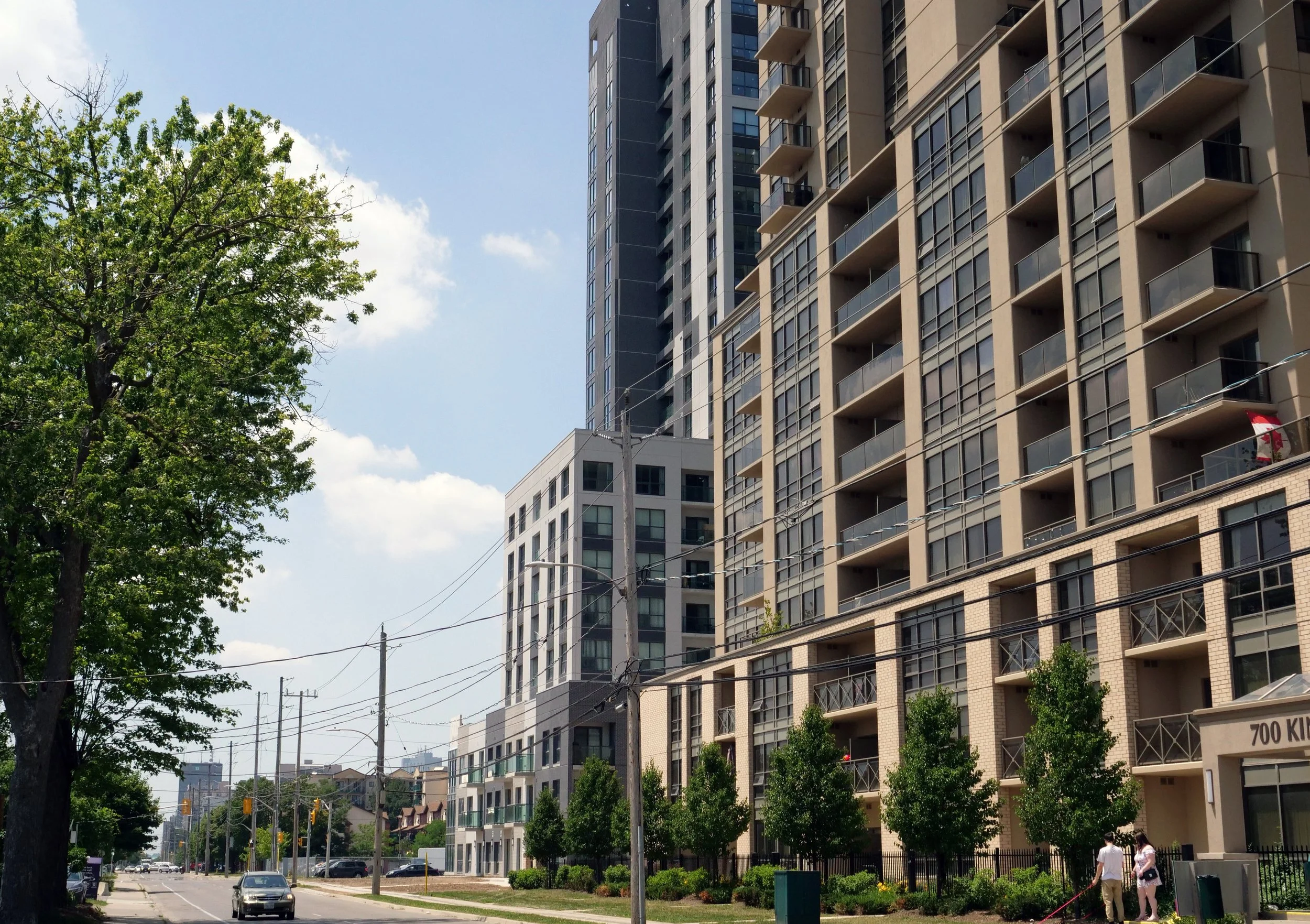
For developers and land acquisition teams, this change in municipal priorities and policy fundamentally alters the math for development potential. The most valuable land is no longer the raw acreage on the edge of town. Instead, underutilized land has transitioned from an urban liability to a valuable strategic asset. Whether these are old factories, aging strip malls, or vacant lots, the most potent opportunities are now located, both conveniently and inconveniently, in the heart of our cities.
However, the revitalization of these sites is not a simple process. Mechanisms to increase density are hidden inside multiple layers of policy. To illustrate this complexity, I’m looking at London, Ontario—a city that has become a significant role model for aggressive intensification policies. I’m also going to show how Ratio.City can be an indispensable platform to help de-risk these complex projects, allowing stakeholders to visualize and identify the hidden density within their cities.
London, Ontario
To understand how different policies impact density, we’re looking at London, Ontario. The city is a good example of how municipal, federal, and provincial policies all combine to impact allowed density. I review the following policies: the municipal London Plan, adopted by the City Council in 2016, which set the initial development boundary for the city, the Federal HAF funding (signed in 2023), which accelerated changes in zoning permissions, and Provincial Protected Major Transit Station Areas (PMTSA) mandates (2024), which have further intensified density targets.

The Municipal Foundation: The London Plan
At the municipal level, London has drawn a hard line in the sand against outward sprawl with The London Plan, adopted in 2016, establishing a strict Urban Growth Boundary and a mandatory target that 45% of all new residential development must occur within the existing built-up area of the city (City of London, 2025). This policy acts as a constraint on sprawl, directing growth back into the city centre. For developers, this renders underutilized sites as especially attractive areas for development; however, these sites require zoning that supports the necessary density to make redevelopment viable.
The Federal Catalyst: The “HAF” Effect—Why land values have changed
While the London Plan set the initial goal for inward growth, newer federal programs are also providing incentives to focus on inward growth. In September 2023, London became the first city in Canada to sign a Housing Accelerator Fund (HAF) agreement, a federal program administered by the Canada Mortgage and Housing Corporation with the aim of creating at least 100,000 new housing starts (CBC News, 2023).
To secure the $74 million in federal funding, the city has committed to a radical upzoning policy: rezoning lands within 1.5 km of higher-order transit stations to permit up to 10 storeys as-of-right (HAF Agreement, London, ON). This policy shift significantly diminishes the “entitlement risk” of developing underutilized land, effectively strengthening the objectives of the original London Plan.
The Provincial & Municipal Alignment: Protected Major Transit Station Areas (PMTSAs) and Bill 312
In addition to existing municipal and federal policies to encourage density, PMTSA’s were introduced at the provincial level in 2024. While the 1.5km radius listed in the HAF agreement broadly upzoned parcels in proximity to transit, PMTSAs are designated regions–generally a 500-800m radius–around a major transit station, which are planned to accommodate an even higher level of density.
In London, PMTSAs present the opportunity to unlock even more densification within the city. On September 24, 2024, the Municipal Council adopted Amendment No. 312 (Bill No. 312) to The London Plan, further altering the height landscape.
How can Ratio.City help make sense of all these policies?
Ratio.City can help simplify understanding federal, provincial, and municipal policies. Here is how you can use Ratio.City to find density-based opportunities within underutilized land in London:
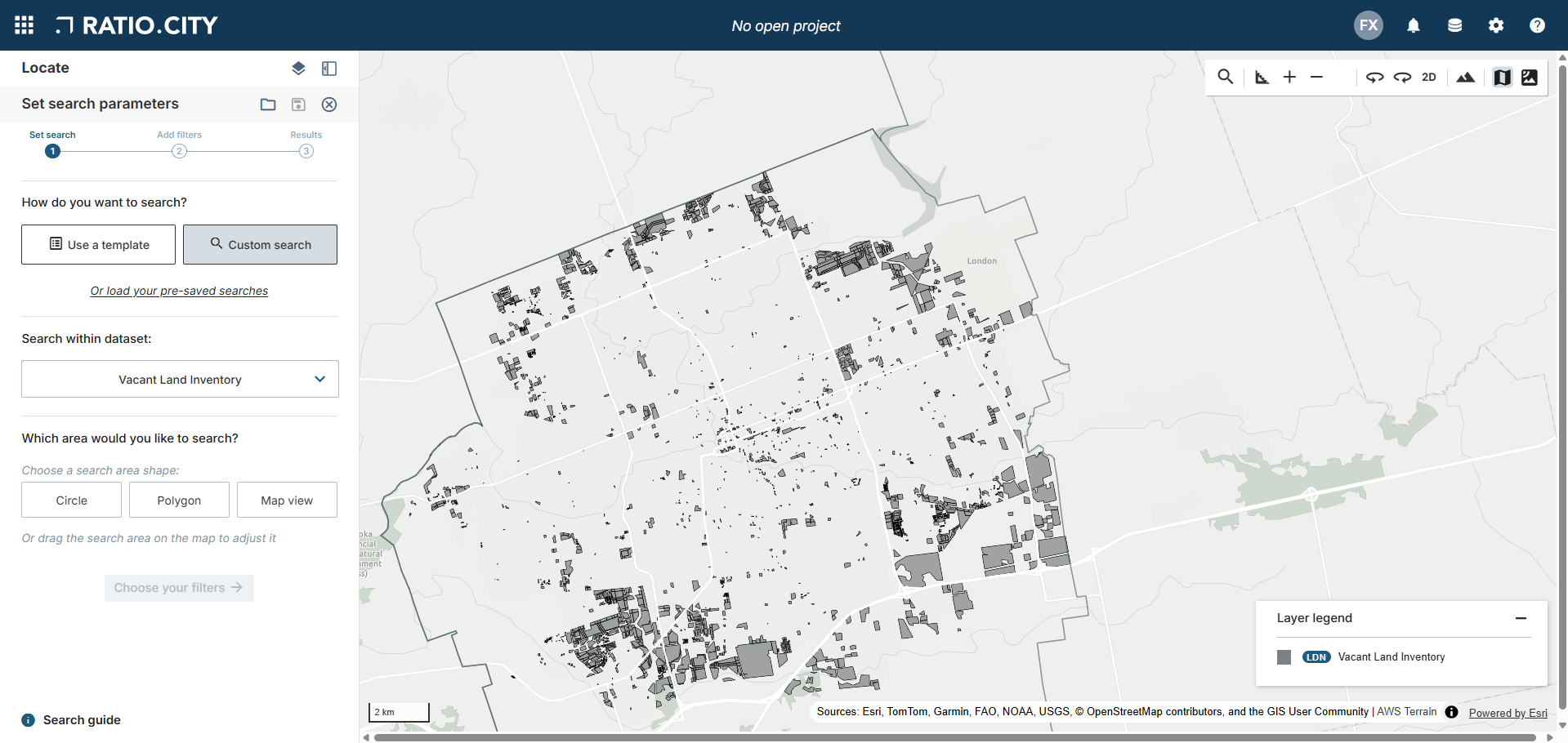
1. The Search
In London, Ratio.City conveniently has a “Vacant Land Inventory” layer (shown in the image below) from London’s open data website (London Vacant Land Inventory). Ratio.City can also provide the percentage of existing coverage of a parcel, as well as the land use (Industrial High, Industrial Light, etc.) for each parcel. Using Locate Mode, let’s identify parcels that are coded as Industrial or Commercial.
2. The Policy Overlay
Once we have done this preliminary filtering to find industrial and commercial sites, we can filter by “Protected Major Transit Station Areas”.
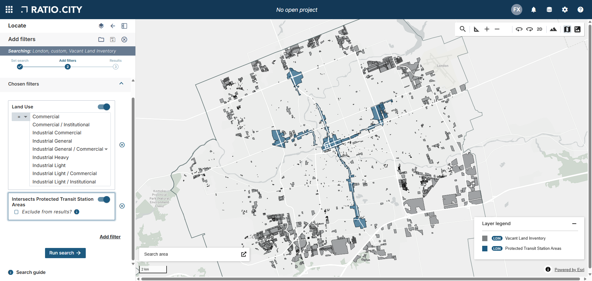
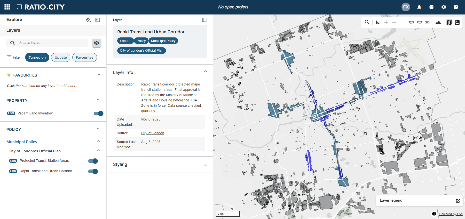
If the underutilized site we located in the search sits within this PMTSA boundary, we’ve hit a policy “sweet spot.” To refine further, we can overlay the “Rapid Transit and Urban Corridor” layer. This will confirm if the site falls under the new high-density provision of Amendment No. 312.
3. The Results
By stacking these layers, we can instantly find sites where much higher density is allowed.
In my own exploration, I’ve identified a couple of areas that present the potential to be sites of high value:
2302 Auto Mall Ave (Industrial Vacant Lot located within a Rapid Transit and Urban Corridor boundary)
149 Wellington St (High-Density Commercial / Residential Vacant Lot located within both a Protected Transit Station Area and a Rapid Transit Urban Corridor)
244 South St (High-Density Commercial / Institutional / Residential Vacant Lot located within both a Protected Transit Station Area and a Rapid Transit Urban Corridor)
58 High St (Commercial Vacant Lot located within a Protected Transit Station Area boundary)
995 Hargrieve Rd (Industrial Vacant Lot located within Protected Transit Station Area boundary)
It was interesting to find that despite all the policies in place to incentivize inward growth using underutilized industrial land within transit zones, filtering with Ratio.City presented a limited number of parcels that successfully fit into these categories.
Conclusion
To find the real value, you need to layer policy, incentives, and physical constraints into a single view. With Ratio.City, users can instantly stack these critical layers—visualizing the convergence of transit corridors, brownfield incentives, and zoning bonuses in a single environment.