Data Driven Cities: The importance of digitizing planning data for future growth
If you think the current planning system is antiquated and inefficient with its reliance on physical documents and data scattered around in varying digital formats, you’re not alone!
While it's true that urban planners are moving away from extensive paper usage, they work with a lot of data, often in different physical or digital formats (maps, documents, emails, and plans etc.) that make utilizing the data difficult and inefficient. As technology races ahead, keeping up with demands feels like a never-ending chase. Projects are becoming increasingly complex, with a growing volume of data generated. Managing and tracking that data becomes difficult.
How does Ratio.City tackle this data problem and collate our current database of planning data on our platform?
One of the solutions is a process called digitization: the process of converting geographic features on an analog map into digital features that can be readable on computers.

Digitization: Converting features from analog maps into computer-readable digital formats.
What is digitization in the context of urban planning?
For planning data, this involves adding geographic and spatial components to the datasets so they can be read and used by digital mapping software. This may require the tracing of roads, boundaries, rivers, and other geographic features from images, scanned analog maps, into digital points, lines, and polygons. You can then go a step further and georeference digital data, which is when geographic coordinates are added to those map features.
Why drown in a flood of spatial data scattered across formats and systems like paper maps and documents, siloed spreadsheets, and endless email chains, where keeping track of documents and updating them is time consuming and difficult, when you can go digital and spatial?
At Ratio.City, our data team digitizes and georeferences some of these planning datasets, making them easily accessible alongside all our other data!
The benefits of digitizing spatial data
Efficiency-streamlining operations to enable automated workflows
Once all the spatial data has been digitized into formats that can be used with digital mapping software, it can be stored and accessed conveniently in one database. This makes it easier to use software to quickly make updates, sort through/organize data, and run analysis. Automated scripts and workflows can be developed to automatically update or run analysis.
Better data management
Imagine having all your data at your fingertips, neatly organized and ready to go in one database or interactive map on your computer! If you or someone on your team would like to update, search, conduct analysis, or sort through the data, they can do it quickly on the computer with a few clicks, uncovering more relationships between them.
Greater data accessibility leading to improved customer experience and increased collaboration
If data is stored in an online, cloud, or server database, people can easily access the same data on their computers from any location. If you are working on an urban planning project with many project stakeholders, you can show them an online interactive map showcasing all the project data. Collaborators can view the data on the map from anytime, anywhere, and easy interactivity allows them to comment and share insights quickly and easily.
Don’t get me wrong – emails and meetings have their place, but there are more efficient ways of collaborating, which leave less room for errors and miscommunications.
How our platform is fostering collaboration in urban planning?
Smart cities and minimizing environmental impact
Digitizing spatial data and maps has the added advantage of allowing more detailed monitoring and management of natural resources, land use, and human activities, which support sustainable and smart city practices.
Challenges of spatial data digitization
Incomplete or low quality data leading to inaccuracies
Sometimes non digitized data is incomplete or once they are scanned, they are low quality. This can lead to inaccuracies when tracing maps. Manual data entry is also susceptible to human error and can compromise the integrity of digital data
Digitization and spatialization is a time-consuming process and a potentially costly endeavor
Non-digitized documents can be in various formats (paper/paper maps, images, etc.). Each format has its own challenges in terms of readability, data extraction, and compatibility. The process of acquiring, sorting, and converting these documents’ data to be digitized can be time consuming, especially if it involves a lot of tracing. This makes the process a potentially costly endeavor that requires specialized skill sets.
Exciting new developments in the field of AI means that new tools are available that can help do this quickly and automatically. However, industries like urban planning have a responsibility to ensure accuracy, reliability, and trust in data because decisions using this data will shape the future of cities.
Interoperability and integration with existing workflows and systems
Transitioning from working with non-digital data to one with increased potential for automation and digital data solutions can be challenging to plan and implement.
How should we overcome the challenges of digitization?
1. Evaluate current processes to easily plan for the transition. Identify difficult areas and places for improvement.
2. Invest in automation to streamline data handling processes.
3. Enhance data quality control to improve and validate data accuracy throughout the digitization process. This includes standardizing data formats to enhance consistency and compatibility across systems.
Viewing digitized data and other layers on the Ratio.City platform
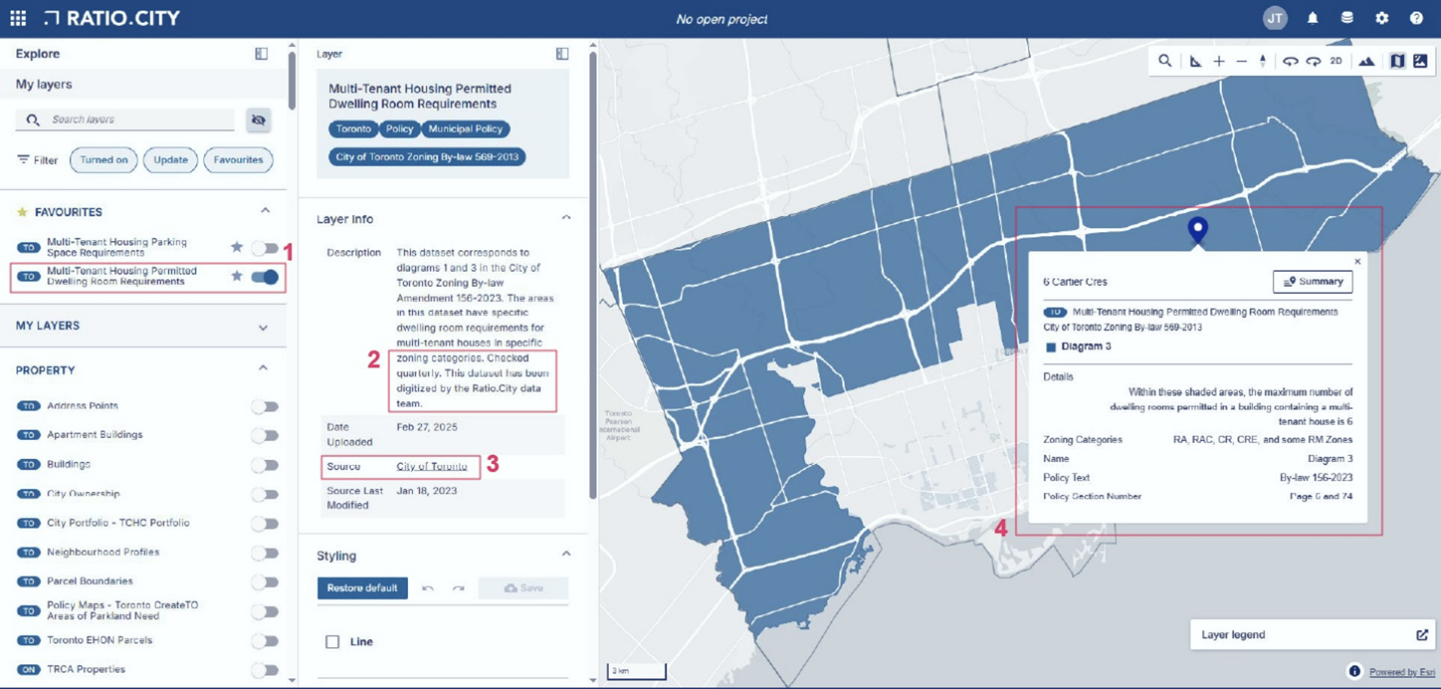
Clicking on the features on the map to generate a pop up providing more information about the dataset.
1. On the layers panel toggle any layers on or off.
2. The layer description provides information on whether the layer was processed or digitized and how frequently it is checked by the data team for updates.
3. This contains the name of the data provider and a link to the original data source. If the layer was digitized, the link will direct the user to the original PDF or image of the hardcopy document.
4. Clicking on the features on the map will generate a pop up providing more information about the specific feature in the dataset.
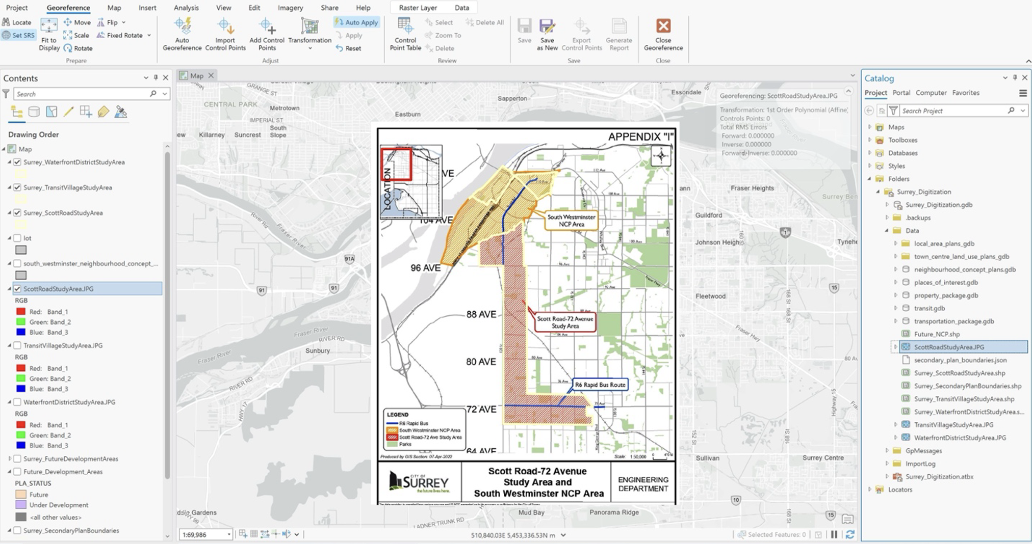
Example screenshot of georeferencing planning data on ArcGIS Pro
Ratio.City makes planning data more accessible than ever. All datasets are available in one place, and if you have a dataset you'd like to see digitized or spatialized, just reach out to our team! The georeferenced datasets on the platform are valuable. You may not find them anywhere else in that format.
Envision seamless collaboration with planning departments, developers, and all involved collaborators where everyone is looking at the same datasets at the same time!
“Access to data is very important and right now we have a really difficult issue where data is often very siloed. It is difficult to get a clear understanding of the bigger picture of housing supply, housing demand, and affordability. Ratio.City is a one-stop shop providing access to data and collaboration tools. You can think of Ratio.City as a data librarian. We’re collating and cleaning up all of this data and making it accessible. – Cait Brock, Product Manager at Ratio.City